Politics & Government
Planning Commission Weighs in on City Avenue Rezoning
Commissioners said they would like the proposal to be more pedestrian-friendly.
In a special meeting Tuesday night to discuss the proposed rezoning of City Avenue, members of the Lower Merion Planning Commission expressed concerns about the reduced Floor Area Ratio for new development and said they would like to see additional efforts to ensure that the proposal is pedestrian and public transit friendly.
The Planning Commission simply talked about the township’s proposal to economically revitalize the area, but on Nov. 7, the commission will be asked to make a recommendation on the ordinance to the Lower Merion Board of Commissioners' Economic and Revitalization Committee.
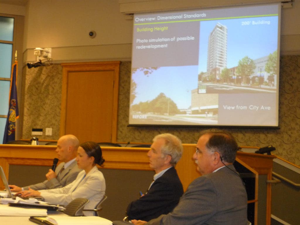
Planning Commission Co-Chairman Robert Gray said the township’s decision to reduce the FAR for redevelopment to 1.75 “may well be counter-productive to what we’re trying to accomplish in the ordinance” and he suggested that the township revisit the issue. Floor area ratio means the proportion of total floor space in a multi-story building to the size of the lot.
Find out what's happening in Narberth-Bala Cynwydwith free, real-time updates from Patch.
Bob Duncan, director of building and planning for the township, said the FAR reductions are a direct response to the public’s comments that there was too much density. Duncan also said he thought a 1.75 FAR was still reasonable.
Planning Commissioner Charles Howland said he thought what Gray was trying to say is that the reduced FAR would make the area less pedestrian-friendly because there would be “big gaps” between the buildings.
Find out what's happening in Narberth-Bala Cynwydwith free, real-time updates from Patch.
Howland said it is “not that it’s not developable, but that it’s not as walkable because of big gaps.”
Earlier in the conversation, Commissioner Brian O’Leary said he was concerned about the decreased FAR and the potential for increased traffic from new development.
“We’re going to get ugly (buildings) and a lot more traffic,” O’Leary said.
In its latest review and recommendations about the City Avenue rezoning proposal, the Montgomery County Planning Commission, in a letter to the township, said “any further reduction in FAR limits would seriously jeopardize the ability to create an active pedestrian environment.”
The county planning commission said in the letter that its concern is that tall buildings and a low FAR could lead to a “suburban office campus style of development…similar to what currently exists in the proposed district.”
Commissioners also talked about ways to make the proposal more pedestrian-friendly and encourage public transit.
That discussion began after Planning Commissioner Alan Ritterband asked Duncan how he has been addressing the public’s comments that a comprehensive plan for the City Avenue rezoning proposal should have come first, before the ordinance proposal.
Duncan said “It’s a legitimate concern, but I think we’d ultimately be back here…I don’t think the master plan would address the specifics of the ordinance.”
Gray said he thinks the ordinance does articulate the township’s goals of what it’s trying to accomplish with the rezoning, but he thinks there is still an opportunity to strengthen the goals of pedestrian links and encouraging public transit.
In response to public comment that the proposal should be more pedestrian-friendly, the township recently added a new incentive for developers under the proposal which would give developers an additional .25 FAR over the permitted 1.75 FAR if they built a public multi-purpose trail.
The multi-purpose trail would connect one end of the developer’s property to the other so that residents could walk or bike through the property rather than using existing roads, Duncan told Patch after the meeting.
The trail would measure at least 8 feet in width and be paved with asphalt.
Gray said the pedestrian trail “has the opportunity to become a more significant element here.”
Gray said he would like the township to consider attaching to the ordinance a requirement that an official map for the proposal be produced and that it would include “significant public space and significant pedestrian linkage.”
When Gray was asked how a map could be done when no one knows where the new buildings will be, Gray said the township could include on the map what is there now and make projections about where pedestrian linkages will be.
Planning Commissioner Brian Hirsch said he was concerned about not having a comprehensive plan because the goal of pedestrian-friendly is “not clearly articulated” in the ordinance and “mass transit doesn’t seem to be built into the plan.”
Hirsch said he would like to see a higher ratio of residential units because, “if you want people walking around, you need people living there.”
Duncan said everyone thinks of trains when they hear the word mass transit, but here are several bus routes that travel through the City Avenue corridor.
SEPTA told the township that if it creates the need, then it will bring in more busses to meet the need, Duncan said. SEPTA is receptive to the idea of bringing buses onto larger development sites as long as the ridership is there, Duncan said.